
If you’ve visited any of the United States’ sixty three national parks, chances are you either drove through or parked your car and set off on foot. Though a hike or slow drive are both great ways to take in the scenery, cycling lets you get up close and personal to national parks’ stunning landscapes, breathtaking views, and memorable details.
Many park roads are open to cyclists, and you can ride the same loops and sightseeing routes as any vehicle. Some destinations, like Montana’s Glacier National Park, offer seasonal cyclist-only access, leaving you to own the road without fear of traffic.
Drive in with your bike, or—if you’re lucky enough to live near a national park—ride in and camp for an extended getaway. If you have some cycling experience, a geared bike, and a curiosity about the nation’s most celebrated natural wonders, redesign your next national park visit and see firsthand what you and your wheels are capable of.
- Glacier National Park
- Theodore Roosevelt National Park
- Saguaro National Park
- Acadia National Park
- Mount Rainier National Park
- Shenandoah National Park/Great Smoky Mountains National Park
- Cuyahoga Valley National Park
- New River Gorge National Park
- Indiana Dunes National Park
- Big Bend National Park
- Planning Tips for Biking National Parks
Glacier National Park

Montana’s Glacier National Park is a dream destination thanks to its peaks, pines, and incredible geological history. The park’s distinct formations were created by the movement of Ice-Age glaciers tens of thousands of years ago.
It’s easy to imagine massive glaciers carving their way through the land once you’re in the park—valleys, rugged slopes, and lakes greet you immediately, and can be enjoyed up-close or at a distance.
Going-to-the-Sun Road is the main road that cuts horizontally through the park. Said to be named after a spirit sacred to the local Blackfeet tribe, the 50-mile road connects the East and West entrances of the park. Its highest point, Logan Pass, features a large visitor center and staggering views from an elevation of 6,646 feet.
Cycling this road is a feat that requires patience, stamina, and dedication. The climb is not easy, but manageable for experienced riders.
The eastern section of the road, starting at St. Mary, features Saint Mary Lake. Meanwhile, the western portion follows the shore of Lake McDonald. Expect a steep but exhilarating downhill after you reach Logan Pass from either direction.
Additionally, keep in mind that the climb from west to east is longer. You’ll want a bike with a wide range of gears to keep your ascent steady and well-paced.
If you’re looking for a shorter and easier foray to get your adrenaline going, consider biking only the shore of Lake McDonald. And don’t miss the swimming areas along the way!
In the spring, Going-to-the-Sun Road is officially closed to cars and filled with cyclists enjoying the rare space and smooth surface without the drone of engines. Spring is hands-down the best time of year to bike Glacier, since summer brings balmy temperatures but more traffic.
If you do plan to get on the road in the summer, choose a weekday to avoid congestion, and start early to avoid the heat.
There are some cycling restrictions in place between June 15th and Labor Day, so plan accordingly! Highlights along the way include Bird Woman Falls, ice-topped Heaven’s Peak, and the crystal-clear Sprague Creek.
Theodore Roosevelt National Park

Often overshadowed by the South Dakota Badlands, North Dakota’s Theodore Roosevelt National Park is a worthy counterpart. Painted buttes, rolling terrain, and a winding 36 miles of paved road are open to drivers and cyclists alike.
Starting and ending in quaint Medora, the South Unit Loop follows the rims of rock walls, carved to perfection by ancient river flow. The road is curvy but not excessively steep, and includes fun pit stops like the prairie dog village and Scoria Point Overlook.
Watch for heavy summer traffic, wildlife, and occasional cattle grates—you’ll have to carefully walk your bike over them.
Bison sightings are not uncommon, and prairie dogs dot the roadside. These badlands will vary from a deep red to a subtler ochre, and turn bright green during a wet summer, while sunset and sunrise highlight the unearthly palette.
The park’s rugged North Unit is also open to cyclists, but is known to be more isolated and distanced from services.
Medora itself is a tourist hub with enough history, shops, and dining to keep you busy all day. Dakota Cyclery is located steps from the park entrance for your pre-ride tune-up, and campgrounds and lodging are readily available.
For more experienced mountain bikers, the southwestern corner of the state is also home to the Maah Daah Hey Trail network, featuring 144 miles of off-road adventure running through the badlands. Pick a segment and shred, surrounded by the country’s wildest hills.
Saguaro National Park

A favorite among southern Arizona’s local cycling community, Saguaro National Park combines one-of-a-kind vistas, easy access, and perfect winter weather.
Divided into two sections that hug Tucson from both sides, the park has several roads open to cyclists that are easy to reach from the heart of the city.
In the Eastern district, Cactus Forest Loop Road is one of the quickest and most popular introductions to the park. This 9.5-mile loop has enough climbs and descents to keep your heart pumping, multiple overlooks, and lively native fauna and flora in all seasons.
On the western side of the park, the 6-mile, mostly-gravel Bajada Loop Drive is a great option for those looking to try their hand at gravel biking. You’ll want to have a gravel or mountain bike with wide tires for maximum comfort and accessibility.
Tucson’s roads are famous for their summertime abundance of Goathead thorns, tiny but vicious burs that love to stick to anything with air in it. Be prepared for flats—try buffing up your tires with tube sealant and carry a repair kit containing a spare tube, tire levers, and a hand pump.
It goes without saying that the Sonoran Desert gets pretty warm, so avoid riding in the middle of the day during hotter months. Be sure to carry an all-day supply of water, as well.
If you’re a summertime visitor, be aware of road flooding caused by the sporadic monsoons that keep the desert vibrant.
Acadia National Park

There’s no better remedy for the heat than coastal Maine’s rocky shore, fir forests, and shady, tree-lined paths.
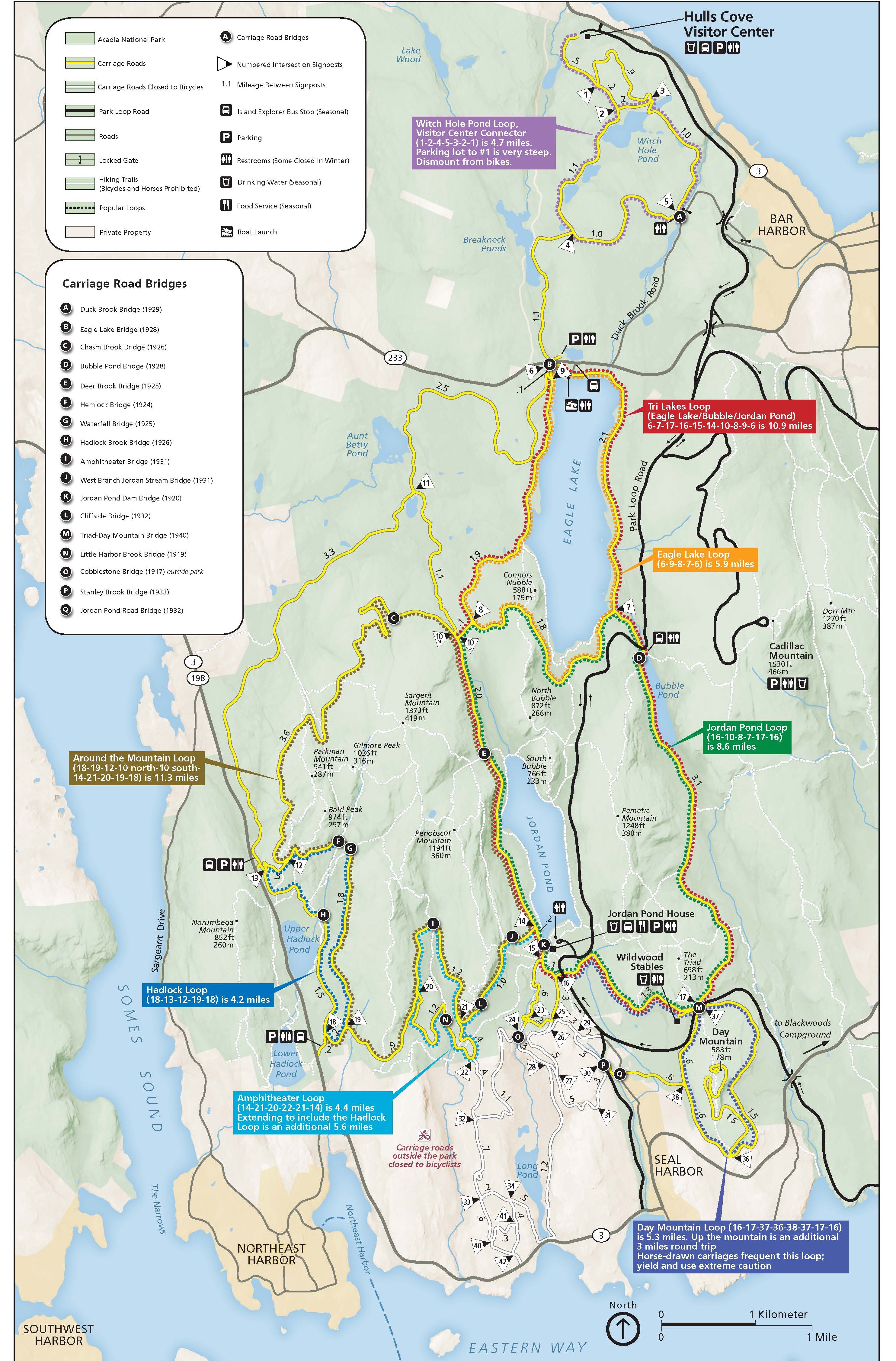
Located on Mount Desert Island, Acadia National Park is open to cyclists of all levels and features one of the area’s best-kept riding secrets—nearly 50 miles of gravel carriage roads, spearheaded by John D. Rockefeller as horse trails and repurposed to accommodate bikes.
Acadia’s most famous road is, without a doubt, 22-mile Park Loop Road, which follows the eastern shore of the park. Gorgeous but congested, this road is open to cyclists—but be warned: it gets crowded and narrow, and features plenty of blind spots.
The park’s carriage road network, open in summer and fall, does not allow vehicles and provides a safer alternative. This system connects multiple trails, so you can customize your trip based on where they intersect.
Concentrated in the east, the roads ferry you through the interior of the island, crossing original stone bridges along the way. Consider Hulls Cove as an entry point—use this map to orient yourself! Keep an eye on storm and wildlife closures while planning your trip, as well. Early spring rains tend to get the paths muddy, and mud closures are not uncommon.
Make Bar Harbor your home base for exploring Acadia. The seaside town will take care of all your bike needs, and Main Street is lined with shops, restaurants, and diverse local businesses.
Acadia is your taste of New England, and biking the carriage roads is the best way to get to know a less-traveled part of Mount Desert Island throughout your visit.
Mount Rainier National Park

If you’re looking for an alpine challenge, Washington’s Mount Rainier National Park checks all the boxes. Steady elevation gain, majestic views, and Northwestern woodland makes the park an outdoor enthusiast’s playground. Make the climbs by bike, and you’ll feel at the top of your game as you reach heights well over 3,000 feet.
Two hours from Downtown Seattle, the park’s Nisqually Entrance launches you onto Paradise Road, a 19-mile climb ending at the historic Paradise Inn and an adjacent visitor’s center—and yes, there are burgers!
Ringed by mountaintops and sitting at 5,400 feet, the Paradise meadows are often blanketed with wildflowers, and it’s easy to spend a few hours’ rest in the area after your ride. Beautiful but popular, this road tends to have high traffic, so consider avoiding weekends and peak hours.
Right behind Paradise Road, Sunrise is the next best-known option for those entering the park from the White River entrance. Totaling 14 miles one way out of the north east, the stretch leading to Sunrise Point is part of the state’s highest paved road.
Ending in the foothills of Emmons Glacier, the ride opens up to all-around views of not only looming Mt. Rainier, but surrounding peaks as well.
Start early, break a personal record, and get to know the Cascades personally on your next Northwest expedition.
Shenandoah National Park/Great Smoky Mountains National Park

The Appalachians are no Rockies in terms of elevation, but the Eastern range boasts some of its own unmatched characteristics.
Cycle the Blue Ridge Mountains in Virginia’s Shenandoah National Park to see the land of gaps and hollows, as made popular in folk legend and lore. Skyline Drive, which cuts diagonally through the park and is open to cyclists, starts in Front Royal and ends at Rockfish Gap, where it turns into the famous Blue Ridge Parkway.
Skyline Drive itself totals 105 miles one way, making it a good option for a multi-day excursion or a section ride. For overnighters, Big Meadows is a conveniently located halfway point, featuring a campground and a resort.
The drive is definitely steep, and you’ll be sharing the road with traffic—and the occasional black bear. Elevation dips, rolls, and climbs frequently, as you’ll virtually be following the crest of the range and reaching heights well over 3,000 feet.
Mileposts line the west side of the drive, keeping you updated on progress, and there are a total of 75 overlooks for those moments of doubt, reflection, and snacking. Views of the Shenandoah Valley and the Piedmont are abundant, and the road is categorized as a National Scenic Byway.
This ride is best suited for experienced cyclists who can sustain long climbs. Devoting a few days to the experience would be a great introduction to bike touring, for those who have only done day trips in the past.
If you’re feeling ambitious, start at Front Royal, head 105 miles southwest on Skyline Drive, and don’t stop in Rockfish Gap! Continue on the Blue Ridge Parkway, which can take you anywhere from Roanoke, Virginia, to the gateway to the Smokies in Cherokee, North Carolina. Take the plunge in autumn to witness the area’s incredible foliage and take advantage of the cooler climate!
Speaking of which, Great Smoky Mountains National Park rivals Shenandoah in its rocky ridges, native forests, and Appalachian history. The park’s Cades Cove Loop is a significantly milder ride for those looking to spend only a few hours on the bike.
This 11-mile loop is closed to vehicles on Wednesdays during the summer season, and there’s even a bike rental service available right at the Cades Cove Campground. All you have to do is pick your cruiser, get on the road, and admire the sights.
Cuyahoga Valley National Park

Sitting between the urban centers of Cleveland and Akron, Cuyahoga Valley National Park is a rare oasis in suburbia, easily accessible from both metro areas.
Waterfalls, streams, and greenery fill the park, which offers 125 miles of hiking trails to let off that city steam. For a slightly hilly but not exceedingly challenging day ride, hop on the park’s Towpath Trail, which runs along the former route of the Ohio & Erie Canalway.
Lock 39, Station Road Bridge, Ira and Lock 29 Trailheads all offer access to the trail, as do the villages of Boston and Botzum.
If you choose to only ride the trail one way, the Cuyahoga Valley Scenic Railroad—one of the park’s main draws—accepts bikes onboard and can bring you back to your starting point in minutes.
If the Towpath alone doesn’t satisfy, take your trip a step further by joining up with the Ohio & Erie Canalway Trail in Cuyahoga County.
The trail totals over 80 miles one way, and links Cleveland’s Lake Erie shoreline to Portsmouth, Ohio. There are campsites available along the way, and some portions are crushed stone, so strap on your widest tires before tackling the historic towpath.
New River Gorge National Park

One of the most recent additions to the National Park System, New River Gorge National Park had a reputation as a mountain biking destination even before its new title.
Perched along the banks of West Virginia’s New River, the park is ideal for beginner mountain bikers, with miles of maintained trails ranging from easy to intermediate.
Totaling 12.8 miles between them, the park’s four Arrowhead Trails are the place to start if you’re looking for a basic introduction to mountain biking. All four are loops, and range from 1 to a little over 6 miles.
A rock bridge, gorge views, forested bends, and a rhododendron garden are only a few of the natural highlights this trail system is hiding.
Indiana Dunes National Park

Another one of the country’s youngest parks, Indiana Dunes National Park makes for a perfect ride out of Chicago and its suburbs.
Nearly 40 miles of connected trails span the park’s 15,000 acres, guiding you through a unique lakeside habitat filled with shorebirds, wetland waterfowl, and prairie plants. Coastal and wooded at the same time, the Indiana Dunes are a freshwater rival to any seaside destination.
The gravel-based Calumet Bike Trail and the paved Prairie Duneland are the two longest rides at 19 and 22 miles long, respectively. Shorter jaunts include the Porter Brickyard and Marquette trails, both paved and under 10 miles.
Big Bend National Park

For a truly remote cycling experience, Big Bend National Park promises a tranquil desert with less crowding than you might see at other national parks.
The closest town with lodging and services is the tiny community of Terlingua, a little over 30 miles from the park. If you’re venturing out to Big Bend, you’re in it for the long haul—so why not make the best of your visit with a cycling challenge?
There are various roads, paved and unpaved, which are open to cyclists year-round. Your choice might depend on whether or not you can arrange for someone to drop you off and pick you up, since many are one-way rides.
The road between Panther Junction and Rio Grande Village offers 20 miles of medium difficulty, as a large portion of it is downhill. While you coast, keep an eye out for the Rio Grande in the distance! Rio Grande Village is equipped with a Visitor’s Center and reservation-based campground, in case you want to stay to see the unbelievably starry skies that illuminate the region by night.
For a longer and tougher ride, follow the Ross Maxwell Scenic Drive from Panther Junction that runs adjacent to the park’s rugged Chisos Mountains. Steep hills abound, and the 35-mile ride is best for experienced riders used to climbing and navigating desert terrain.
The rides out of Panther Junction will require you to be picked up at your endpoint. Don’t risk attempting to do a round-trip once temperatures soar and daylight dwindles.
For a flatter and arguably easier unpaved route, try the 18-mile Dagger Flat Auto Trail. Follow the sandy trail from the paved main road and admire the wild garden surrounding you on all sides. This is not a loop, so you’ll be returning the way you entered.
Big Bend is an ecosystem and landscape that operates on its own terms, so don’t underestimate the power and solitude of the West Texas desert. Carry food and water, invest in park maps, and avoid midday heat.
Planning Tips for Biking National Parks

- Think ahead. Study national park maps, available on the National Park Service website to establish your cycling start and end points.
- Keep an eye out for construction, road maintenance and weather closures. Most recent announcements can be found on your park’s homepage.
- Wear a helmet! Most national parks require cyclists to don a helmet while riding.
- Be ready to pay an entry fee. While costs are usually reduced if you’re entering a park by bike, the entry fee still applies to everyone. Some park entrances, like the entrance to Glacier National Park at St. Mary don’t accept cash. so bring your card just in case.
- Be aware of and do not disturb wildlife. Some western parks are grizzly bear territory, so bring bear spray and proper food storage bags if you’re planning on staying overnight.

- For those embarking on a multi-day bike tour, note that some national parks offer special campsites for those hiking and cycling. These sites give travelers dirt-cheap rates, are usually first-come, first-serve, and don’t require reservations. Be prepared to share your site with fellow travelers!
- Find out ahead of time if it’s a loop or one-way trail. Loops are especially helpful to cyclists, since starting and ending at the same point makes it easier to park your car or be picked up. If you choose a straight road that starts and ends on two different sides of a park, make sure you arrange pick-up or are able to cycle back. Some parks also offer shuttle services via buses equipped with bike racks.
- Remember basic safety precautions. Stay to the right, remain aware of vehicles and RV’s, and ride safe!
via GIPHY
Whether you’re staying local or traveling across the country, incorporating cycling into your national parks experience is a game changer. Stray from the beaten path and put yourself out there as you travel the landscape, feeling less like a tourist and more like an athlete. Pick a route that fits your experience, pack your best padded shorts, and pedal America’s natural sanctuaries one breath at a time. When you’ve finished your trail for the day and are ready to hit the showers, be sure to check out your next cycling adventure in one of these parks.
Planning is essential when it comes to exploring these parks. Even though you may not be ready for extreme adventure, planning your first tour is a step in that direction. If you’re taking a longer bike tour, be sure that you’ll be giving your body the right fuel it needs by seeing how to eat healthy on these trips. But most of all, be sure to have fun!